Home Multi-Country Search About Admin Login
Cenozoic
Cretaceous
Jurassic
Triassic
Permian
Carboniferous
Devonian
Early Paleozoic

Search by
Select Region(s) to search
Hold Ctrl (Windows/Linux) or Command (Mac) to select multiple
Huai Hin Lat Formation
Click to display on map of the Ancient World at:
Huai Hin Lat Fm base reconstruction

Huai Hin Lat Fm


Period: 
Triassic

Age Interval: 
Upper Triassic (Carnian-Norian) (13, 14, 15)


Province: 
Indochina Block: Khorat Plateau, Indochina Block: Loei Fold Belt

Type Locality and Naming

Type section: Along Huai Hin Lat of Chum Phae district, around Km 108 on Khon Kaen- Loei highway, about 18 km southwest of Pha Nok Khao village; reference sections proposed by Chonglakmani and Sattayarak (1978) along Ban Dat Fa-Ban Kok Kabok-Huai Pakrai section and Ban Lui Lai- Nam Phrom Dam section.

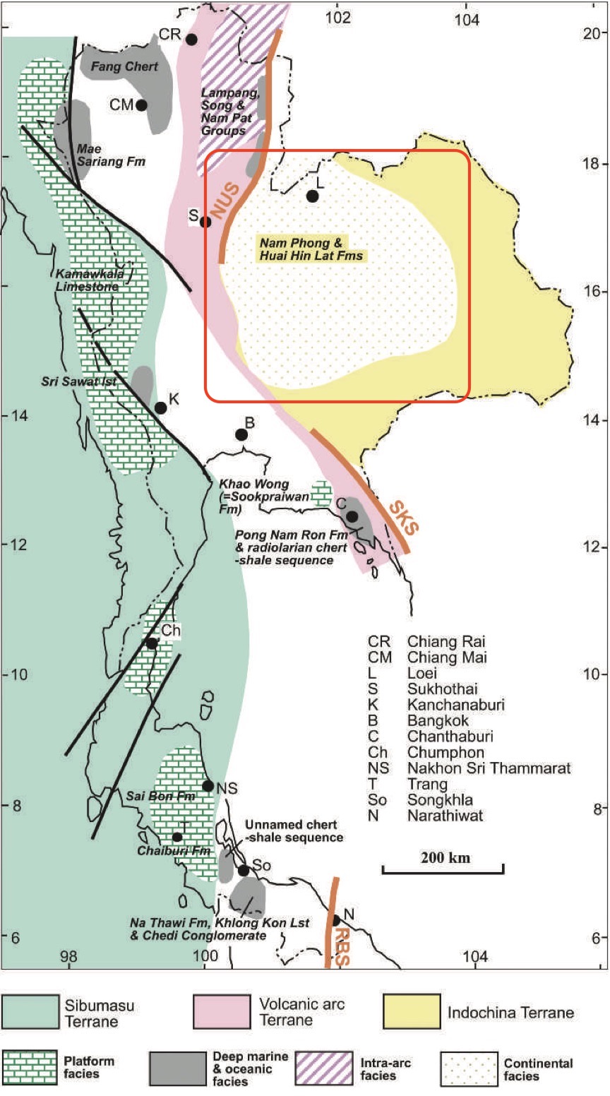
[Figure 1 : Generalized distribution of different Triassic sedimentary environments and some of the more important lithostratigraphic units, and their relations to the terranes. (The geology of Thailand, 2011) page 146]

Synonym: หมวดหินห้วยหินลาด


Lithology and Thickness

Conglomerate, grey to dark grey sandstone; siltstone; black shale and marl. Subdivisions: Into 5 members, upward: Pho Hai Member (tuff), Sam Khaen Conglomerate Member, Dat Fa Member (shale; Norian), Phu Hi Member (clayey sandstone), and I Mo Member (clayey sandstone). Thickness: 140 m at its type section, 1,300 m at Kok Kabok village


Lithology Pattern: 
Clayey sandstone


Relationships and Distribution

Lower contact

Major unconformity (Indosinian I Event Unconformity = Middle Triassic) onto the Hua Na Kham Fm of late Permian..

Upper contact

Unconformably (unconformably = Indosinian II Event) below the Nam Phong Fm (base of Khorat Gr)

Regional extent

NW margin of the Khorat Plateau


GeoJSON

{"type":"Feature","geometry":{"type":"Polygon","coordinates":[[[100.86,17.97],[100.84,17.82],[100.73,17.64],[100.5,17.26],[100.28,16.84],[100.18,16.41],[100.28,15.88],[100.48,15.55],[100.45,15.3],[100.53,14.96],[100.66,14.73],[100.91,14.5],[101.11,14.45],[101.51,14.44],[102.13,14.69],[102.42,14.84],[102.67,14.92],[102.84,14.96],[103.08,14.98],[103.24,15.04],[103.43,15.12],[103.51,15.18],[103.65,15.34],[103.72,15.57],[103.73,16.03],[103.66,16.46],[103.45,16.87],[103.16,17.27],[102.66,17.53],[102.29,17.74],[101.89,17.99],[101.7,17.96],[101.63,17.81],[101.48,17.81],[101.34,17.66],[101.16,17.49],[100.98,17.53],[100.93,17.66],[100.99,17.81],[101.1,17.99],[100.86,17.97]]]}}

Fossils

Plant fossils, Neocalamites sp., Clathropteris sp.

Reptiles are represented by the phytosaur Mystriosuchus sp., a genus which was originally described from the Norian Stubensandstein of Germany and subsequently found in the Norian sediments of Austria and Italy; Turtle and amphibian remains are also abundant, including Proganochelys ruchae and Cyclotosaurus cf. posthumus, respectively. A bone fragment of a Late Triassic plagiosauroid amphibian has also been found. Fishes include a ptychoceratodontid lungfish and the actinopterygians Colobodus cf. sargodon and Semionotus sp. They are very similar to European Upper Keuper fish genera.


Age 


Age Span: 

    Beginning stage: 
Carnian

    Fraction up in beginning stage: 
0.7

    Beginning date (Ma): 
231.02

    Ending stage: 
Norian

    Fraction up in the ending stage: 
0.7

    Ending date (Ma):  
215.23

Depositional setting

Fluvio-lacustrine.


Depositional pattern:  


Additional Information


Compiler:  
Wen Du - modified from- Chonglakmani, C.P., 2011, Chapter 6 Triassic and Booth, J. & Sattayarak N., 2011, Chapter 9 Subsurface Carboniferous-Cretaceous geology of NE Thailand in Ridd, M.F., Barber, A.J., and Grow, M.J., editors, The Geology of Thailand, Geol. Soc. of London.; Lexicon of Stratigraphic Names of Thailand of 2013.